
Google Maps has introduced five new features curated specially for Indian users. The company has used AI to identify and locate landmarks, making it easier to navigate. Google Maps will also start showing an option to choose fuel-efficient routes while driving.
Google has also partnered with local apps such as Namma Yatri, Where’s My Train, and ONDC to digitize the schedule and tracking of public transport. The company is also helping to track the live status of running local trains in Mumbai and Kolkata.
Google Maps Leverages AI to Improve Its Services in India
Among all the new features, one of the biggest additions to Google Maps is the support for localized landmarks, called Address Descriptors. According to Google, the Maps app will now show up to five relevant and popular landmarks when a user searches for a specific place.
Google uses a combination of machine learning signals to display the best landmark, based on the reference of the location. For example: Near ABC bank, school, park, statue, etc. Address Descriptors will be made available to all users in India starting next year.
Google Maps will also directly integrate Google Lens into the app. This will allow users to scan any place on the street to obtain information about the best restaurants, cinema halls, or any other aspect without having to know the name of the place. This feature will start rolling out in January 2024 and will be first available on Android devices.

Live View Walking Navigation will also be added to the Google Maps app. Here, the app will use the phone’s camera to get a live view of the street and display you arrows with exact directions in real-time. This feature will really come in handy in areas with multiple intersections.
Google has scanned over 300 million buildings across India. The company uses AI to scan and display the correct information when a user scans for a place using Lens or Live View Walking.
Google will also allow users to choose a fuel-efficient route while driving. The company says that the app will calculate the best route without affecting the travel time significantly. Google Maps will use real-time data on traffic congestion and road elevation to determine the best route to save fuel.
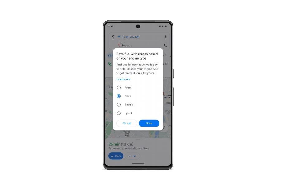
The app can also identify the best route based on your vehicle type. Google says that electric and hybrid vehicles are more efficient in traffic, whereas fuel-powered cars perform better on highways. Considering that Google Maps handles navigation of over 2.5 billion kilometres in India, the fuel-efficient route option is expected to help millions of users.
According to Google, this will not just optimize fuel consumption, but will also reduce carbon dioxide and other emissions in the environment. The company has already deployed this feature in some countries which has helped to reduce 2.4 metric tonnes of emissions since 2021.
Google has also partnered with the Where’s My Train app, where the latest update will now show the real-time running status of local trains in Mumbai and Kolkata. It will also show schematic maps and platform numbers in the app by using Google’s data. More cities will soon be added to this list.
Google has also announced a new partnership with Namma Yatri, a mobility app on the ONDC network. Users will be able to see metro schedules and bookings in the app, which will help to digitize public transport. Google further said that Kochi Metro will soon be added to Google Maps, along with other metros across India which join the ONDC network.